Preparing for the future - more options for more people
The changes will make it safer and easier to walk, scoot, bike, or take the bus to schools, workplaces, sportsgrounds, community facilities, shops, cafes, and businesses.
Berhampore and Newtown are places where a lot more people will be living in the future - close to the central city and Wellington Regional Hospital’s campus, with access to shops, schools, cafes, Massey University, Te Whaea, Wellington Zoo, parks, and the Town Belt. Wakefield Park is a regional centre for sports and recreation.
Many Wellingtonians commute from other suburbs to work at the hospitals, travel to hospital appointments or to visit patients.
Connection from coast to coast
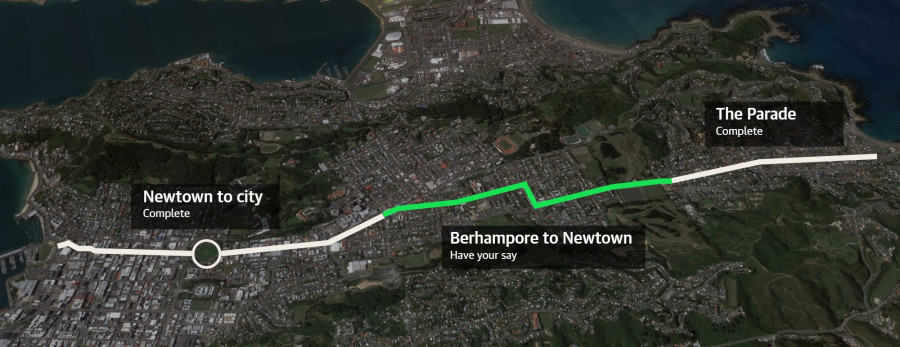
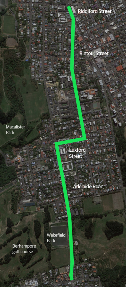
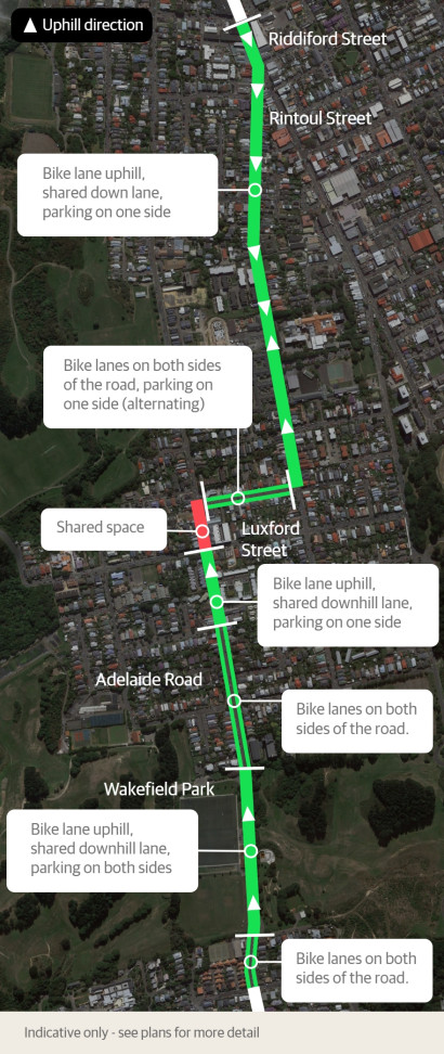
The improvements for people on bikes using The Parade, Adelaide Road, Luxford Street, Rintoul Street, and Riddiford Street will complete the 6.3km safe cycling route between the south coast and central city.
Several changes were made to the plans that went to Councillors for approval:
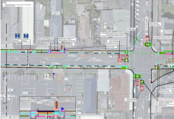
- improving patient access to Newtown Medical Centre on Rintoul Street by widening the footpath by the mobility car park and adding three P60 parks on the opposite side
- changing some parking restrictions at the Rintoul Street shops in Berhampore, changing the loading zone at Berhampore shops to two P10 spaces, and adding a mobility park on Luxford Street
- recommending the inclusion of Lavaud Street in the Berhampore parking zone – this change will be proposed as part of the traffic resolution for the parking scheme consultation in early 2024.
From mid-2022, we began engaging with residents and businesses about planned improvements for people walking, biking, or using buses in these streets.
Following discussions with community groups and stakeholders, changes to our proposed designs included:
- Improving safety for people walking by proposals to reduce speeds through:
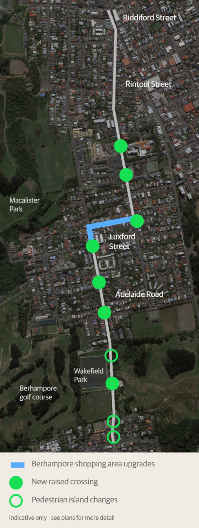
- installing new raised crossings, including on Rintoul Street between Wakefield Hospital and Arvida Village at the Park, at the Rintoul and Luxford streets intersection, and on Adelaide Road at Britomart and Herald streets, Chilka Street and Wakefield Park
- improving visibility at driveways on Rintoul Street, including at South Wellington Intermediate School and Arvida Village
- Improving safety in the Berhampore shopping area through:
- adding a mobility parking space on Adelaide Road (already approved as part of a separate traffic resolution)
- extending the safer speed zone on Luxford Street along to the shops at Rintoul Street
- installing a speed feedback sign for northbound drivers on Adelaide Road
- installing a speed hump on Luxford Street at the left-turn slip lane into Adelaide Road, and judder bars at the BP station entrances/exits to deter red light runners
- Improving safety at the Luxford/Rintoul intersection through:
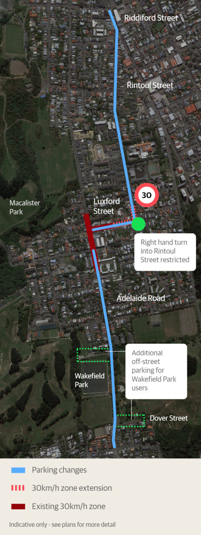
- removing the right turn from Luxford Street into Rintoul Street
- including the lower section of Rintoul Street in the proposed 30km/h zone
- installing a separated northbound bike lane around the corner from Luxford Street into Rintoul Street and providing more space for buses to make this turn by relocating parking
- Retaining the existing parking capacity on Adelaide Road near Wakefield Park through:
- retaining almost all on-street parking around the park
- providing 15 new off-street angle parking spaces on Dover Street
- working with our Parks team to look at options for increasing the amount of off-street parking
- providing more and better bike parking at the grounds
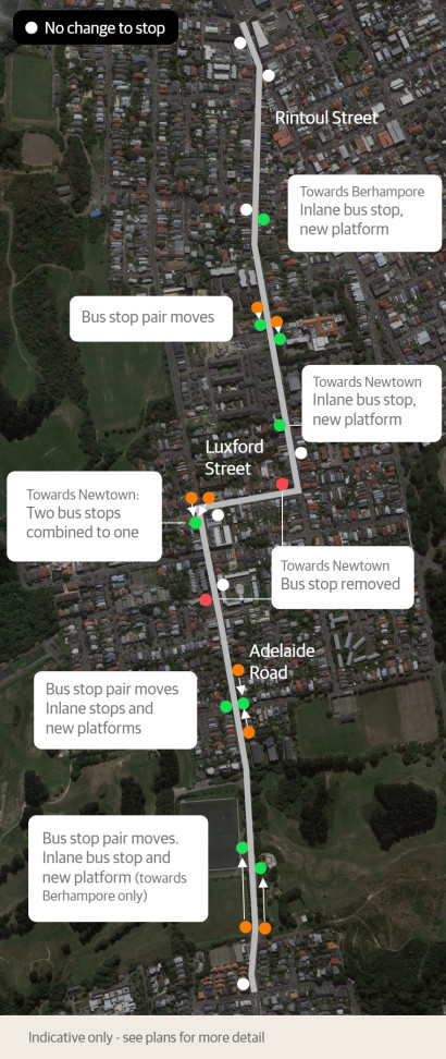
- Improving bus journeys along the route through:
- installing raised platforms at several bus stops and providing more space for buses to pull right into the kerb so it’s easier for passengers to get on and off
- improving visibility on Rintoul Street so bus drivers can see buses coming the other way and buses have space to pass
- combining three bus stops into one new stop at the Berhampore shops
- Providing more short-term parking and loading zones on:
- Riddiford Street and Emmett Street
- Adelaide Road and Herald Street at the Berhampore shops.
As part of our engagement, we’ve spoken to groups in the community and stakeholders to make changes to the proposed designs for the bike/bus route.
These groups included:
- Arvida Village at the Park
- Berhampore Community Association
- Community housing residents
- Cycle Wellington
- Greater Wellington Regional Council (including Metlink)
- Island Bay Residents Association
- Let’s Get Wellington Moving
- Living Streets Aotearoa
- Local businesses
- Local Police and emergency services
- Local schools
- Newtown Residents Association
- Southern Cross Hospital
- Sports clubs at Wakefield Park
- Waka Kotahi NZ Transport Agency
- Wakefield Hospital
- Wellington Hospital
Read a full set of plans and the traffic resolution
You can see the full plans and traffic resolution, as well as other supporting documents.