He tāone e hāngai ana ki te anamata
Preparing for the future – more choice for more people
These street changes are now complete. The changes are making it safer and easier to walk, catch the bus, ride a bike, or scooter. You can read more about the Botanic Garden ki Paekākā to city street changes, including the monitoring and evaluation report on these pages. For questions or comments, you can find the Council's contact details here.
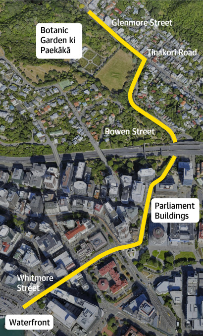
When Councillors approved consultation on a connected citywide bike network plan in September 2021, they also voted to get going quickly on two of the critical routes in the bike network - between Newtown and the city and the Botanic Garden ki Paekākā and the city. To accelerate the delivery of these routes, we are using a new approach using adaptable materials so that interim improvements can be installed quickly, so people can start using the routes faster, and then give feedback and help to refine the design once changes have been installed.
Engagement with businesses on the Newtown and Botanic Garden ki Paekākā to city routes started in November 2021.
To develop the design options for improvements along the route, we worked with technical experts, groups in the community and wider stakeholders.
We then took the designs to the public for feedback between 5-26 July 2022 using a public survey and individual conversations with businesses along the route. Over 700 pieces of feedback informed the designs that went out for consultation, and Council analysed 638 pieces of feedback from individuals and 17 organisations about these designs, alongside advice from technical experts and the working group.
On 11 August 2022, the final designs and community feedback went to Pūroro Āmua, Council’s Planning and Environment, where Councillors approved the route with one amendment – extending the peak-hour bus lane by an hour.
You can read a summary feedback report and all public submissions.
A recording of the meeting and minutes are also available on the Council website.
Data on things like parking use and numbers of people on bikes and buses is being gathered now so we can evaluate the changes in the future.
From the end of 2021, we began engaging with residents and businesses about planned bus and bike improvements along this route.
Following discussions with groups in the community and stakeholders, we changed the initial designs as below:
To allow for business parking outside of commuter hours, we’ve made the following changes:
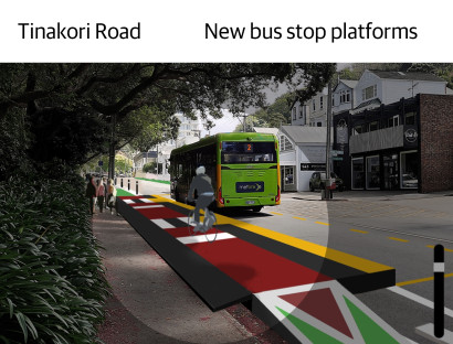
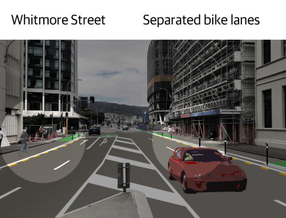
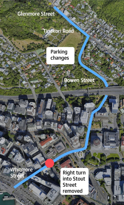
- On Tinakori Road from the Glenmore Street crossing to Botanic Garden to St Mary’s Street, the bus lane has been changed from full time to commuter hours only (between 7am-9am)
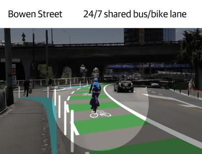
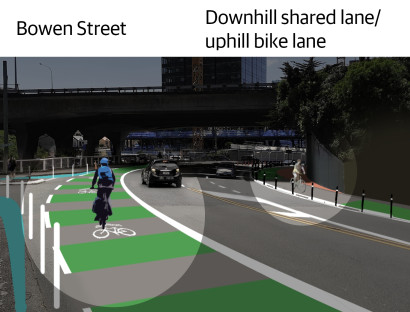
- On Bowen Street near the intersection of Tinakori Road before Sydney Street West, the clearway was proposed to be extended to full-time, but this will remain at commuter hours only (between 7am-9am)
- Changing the Thorndon Residents parking zone boundary to include Patanga Crescent and St Mary Street.
- Extending the bus stop in the westerly direction on Tinakori Road and removing 1 P120 parking space, and keeping 2 P10 parking spaces outside the antique shop.
- Relocating taxi stands from Whitmore Street to Stout Street.
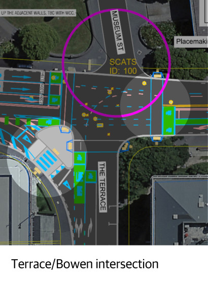
- Installing a mobility parking space on Bowen Street at The Terrace intersection.
As part of our engagement, we've worked closely with groups in the community and stakeholders to make changes to the proposed design.
These groups included:
- Accessibility community
- Businesses along the route
- Cycle Wellington
- Fire and Emergency New Zealand
- Living Streets Aotearoa
- Metlink
- Ministry of Education
- NZ Bus
- Taxi companies
- Thorndon Residents Association
- Waka Kotahi NZ Transport Agency
Evaluating the changes
Once changes have been installed, we’ll be monitoring and evaluating community feedback, local economic data, travel times for buses and traffic and use of short-term parking and loading zones.
Longer term, we’ll be tracking things like numbers of people riding bikes and taking the bus, diversity of people on bikes (age and gender), whether more people think the changes are positive, and kilometres of infrastructure installed per year and how long it takes to get things in.
You can read the full set of plans and traffic resolution
Find out more and read the full set of plans and traffic resolution for the Botanic Garden ki Paekākā to city project.
Webinars
In this webinar (recorded on 15 March) you can meet the team and learn about important street changes that are part of the city's goal to be a net zero carbon capital by 2050. We talk you through two projects - Newtown to the city and the Botanic Garden ki Paekākā to the city. The Council's City Design Manager, Vida Christeller, and project lead Renee Corlett share information about the designs and when the changes will happen. The webinar includes a question and answer session, how you can provide feedback on the street changes once they're made and how to keep in contact with the project team.
In this webinar (recorded on 2 June) we talk you through the new bus stop platforms for the Newtown to the city and the Botanic Garden ki Paekākā to the city projects. The webinar includes a question and answer session with panellists from Wellington City Council, Waka Kotahi, Metlink, Zicla and International Design for All.