He tāone e hāngai ana ki te anamata
A city fit for the future
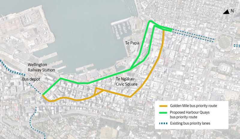
To keep our city moving efficiently and to future-proof our bus network for current and future demand, Wellington City Council and Metlink (Greater Wellington Regional Council) are proposing a second public transport route along the Harbour Quays — between the Wellington Railway Station, along Customhouse and Jervois Quays to near the end of Courtenay Place.
Every weekday, thousands of bus passengers come in and out of the city centre, and demand is growing.
We’re making it easier for more people to move efficiently around our city — using fewer vehicles. By improving how we travel, we can bring more people into Wellington’s central city to work, live, play, and shop. A vibrant and accessible city is one where everyone can get where they need to go safely, sustainably, and with ease.
Why the Harbour Quays bus priority route is needed
A second public transport route through the central city is needed to address current and future capacity and service issues. Buses on the Golden Mile route, which runs along Courtenay Place, Manners Street and Lambton Quay, are often slowed by traffic and by following other buses, and as more people use public transport, these delays are expected to increase.
Project at a glance
The proposed Harbour Quays route links the Wellington Railway Station with Cambridge Terrace and Courtenay Place, following Whitmore Street, Customhouse and Jervois Quay, Cable and Wakefield Streets.
This proposed route will improve public transport along Wellington’s waterfront, making it easier and faster for people to travel by bus while maintaining access for other road users. For the services proposed to move to the Harbour Quays route, we expect they will be between 2 and 6 minutes faster during peak periods.
Improvements include:
- New bus corridor along Customhouse and Jervois Quays, Cable and Wakefield Streets, through to Kent and Cambridge Terraces.
- Part-time bus lanes operating Monday to Friday, 6:30–9:30am and 3:30–6:30pm, giving buses priority during peak times. Outside these hours, lanes are open to all traffic, with clear signage and road markings.
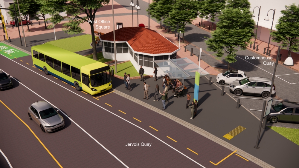
- New and upgraded bus stops near key destinations, including Queens Wharf, TSB Arena, Frank Kitts Park, Te Ngākau Civic Square, Te Papa, Tākina and Embassy Theatre.
All stops will include shelter or canopy cover, seating, and safe, accessible boarding.
Other changes that are needed for the new bus route:
- Reduction of metered parking spaces along the route
- Relocation of tour coach stops to nearby suitable areas
- Adjustment of loading zones to maintain business access
- Removal of the taxi stand on Kent Terrace
- Improvements for pedestrians between Queens Wharf and TSB Arena
bus stop.
These changes are designed to balance transport efficiency with access for all users, making central Wellington easier to reach by bus.

Wellington City Council, as the city’s road controlling authority, and Metlink (Greater Wellington Regional Council), as the public transport authority, are working together on this project.